Oregon: Southeastern: Brookies and Rainbows
Upper Sycan River and North Fork of the Sprague
Nearest town: Beatty and Bly
Nearest City or Large Town: Klamath Falls
Reference Map: Fremont National Forest
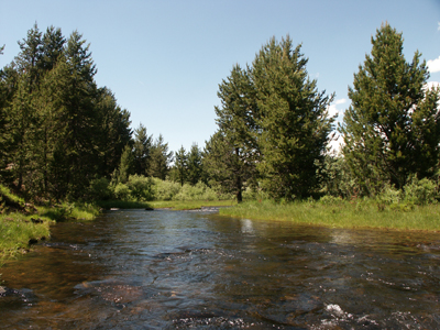
After more than fifty years of trout fishing, I never grow tired of exploring and fishing small trout waters. Chalk it up to therapy or just re-living my youth, but the allure of a clear mountain creek or stream connects me to the Over soul, the ethereal side of fly fishing. The headwaters of the Sycan River and the North Fork of the Sprague River provide two pleasant, mountain retreats for a family with young campers or an old piscatorial prowler like me. Make no mistake, these small waters provide good fishing for 7 to 10-inch rainbows and brook trout with the occasional brown trout. Both waters offer slow gradient and very shallow water with cobblestone bottoms. You have to hike up each creek thirty to forty yards before locating a hole, but every hole harbors at least one 10-inch trout. Besides excellent camping spots, each of these waters has protected wilderness corridors.
As an author of a Montana fishing and camping guide, I am always intrigued with the accuracy and reliance of other guide books. My primary sources were Fishing Central Oregon and Beyond and Flyfisher’s Guide to Oregon by John Huber. Of the two, Fishing Central Oregon is my favorite, but I believe their description of the Sycan is misleading. Their cover shot shows a woman angler holding a large rainbow taken on the Sycan. I checked the spot they touted during run-off after a wet winter. The river was huge, perhaps thirty yards across in the meadow section below the Sycan Marsh. When I returned July 2, the river was a trickle through marshy grass. (Hwy 140 East past Beatty, left on Road 30 to Camp Six, left on Road 27 to the bridge crossing). The authors’ advise searching out logging roads that lead to the river below and finding springs that hold concentrations of trout. Give me a break! The river, emptying out of the expansive Sycan Marsh, is both warm and a mosquito torture test for the most resolved and dedicated of anglers. However, this area would be a fun float in the spring. By mid-summer it is a trickle. From here I headed for Pike’s Crossing Campground.
To reach Pike’s Crossing, continue on Road 30 past Camp Six to the bridge crossing. The campground is just before the bridge on the right. From the bridge the Sycan River runs down trough a wilderness canyon to the Sycan Marsh. Road 019 runs west paralleling the canyon for a number of miles before it veers southwesterly to intersect with Road 3239, which runs north and after a few miles runs close to the canyon, perhaps a mile in some places. I had hoped for more holding water in the canyon just below Pike’s Crossing, but again it was a gentle gradient with few holes or pocket water. The water is ankle to mid-calf deep so traveling upstream is easy. Every hole held a nice pan-size rainbow. I can not report on any other section of the canyon – another time. The water above the campground gets pretty skinny, but there is a nice stretch of a half-mile from the campground to the bridge. In spite of the low flows, the trout are abundant and the canyon is picturesque.
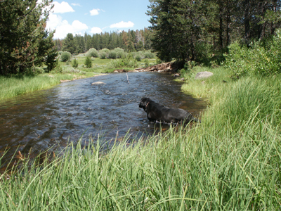
The North Fork of the Sprague River is in close proximity to the Sycan drainage bordering the Gearhart Mountain Wilderness. From Pike’s Crossing continue north on Road 30 until it intersects with Road 28, which leads in a south easterly direction to Ingram and then to the turn-off for Campbell Lake. Take Road 3411 west to the headwaters of the North Fork. This is beautiful meadow country, and the Sprague River is really no more than a willow-lined creek. Two campgrounds, Lee Thomas Campground and Sandhill Crossing Campground, offer great camping spots right on the “river” with plenty of Brook trout hiding along the undercut banks and in the small pools. I left the Sandhill Crossing Campground and traveled a few miles west on Road 3411 and then hiked down into the wilderness canyon. I found the good holding water in the canyon and caught at least 15 trout from 7 to 10 inches in an hour and a half. The entire drainage is scenic, and I never ran into another angler. I have yet to walk into the headwaters from the trailhead.
The North Fork of the Sprague is most easily reached from Bly taking Road 34, which leads past Campbell Reservoir and heads to Dairy Creek. I did not have time to fish Dairy Creek, but it too is beautiful and promising. Both of these waters would be great waters to introduce children to fishing and camping.
Look for more articles on fishing and camping along Highway 395 and Highway 97 in the summer of 2008.
Leave a comment