Duck hunters, start your engines...
October 30, 2007
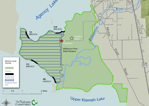
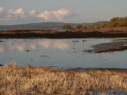
Mark Stern, Klamath Area Conservation Director for the Nature Conservancy, remarked that making a marsh was easy, “Just add water.” That and ten years of planning and engineering, 10 million in construction costs and 200,000 pounds of explosive reversed sixty years of farming practices to add 2,500 acres of new marshland to Upper Klamath Lake and Agency Lake. For thousands of year, the Williamson River deposited sediments across a vast delta where the river enters Upper Klamath Lake. However, in the 1950’s 22 miles of dikes were constructed around the delta and along the river to convert rich bottomland wetland soils into farmland. These barriers channeled the lower Williamson River directly into the lake, which eliminated extensive critical habitat for fish and wildlife, as well as a degradation of the lake’s water quality.
Stern described the shortnose and Lost River suckers, which are native fish only to the Klamath Basin, as the counterpart to the canaries in the mind shaft. Since the early 1990’s, fish and wildlife experts, including those from the National Academy of Sciences, have identified the restoration of the wetlands at the Williamson River Delta as one of the highest priorities for recovery of these two endangered fish, along with other fish and wildlife. Although the channel between Upper Klamath Lake and Agency Lake has always been a natural connection, The Williamson River prior to the 1940’s provided many side channels and marsh that connected the lake, which in turn provided sanctuary for larval fish fry to gradually move towards the lake as they migrated down river from their spawning beds upstream.
Photographs courtesy of Tom Templeton, copyright 2007
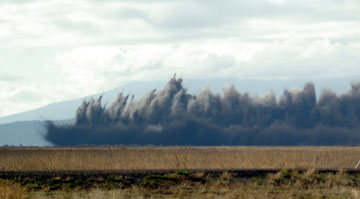
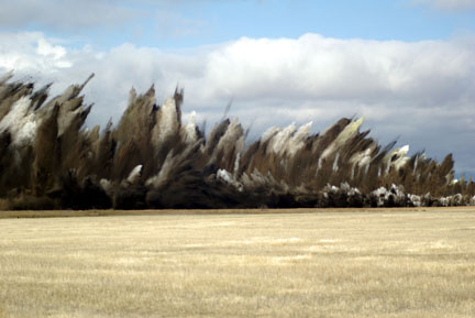
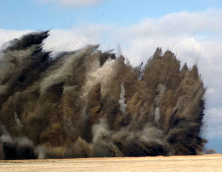
Matt Barry, Williamson River Delta Preserve Director for the Nature Conservancy, has managed the 6,800-acre wetlands project since 2005. In order to get the most bang for their bucks, Matt coordinated with the Bureau of Land Reclamation to create a computer model on the best spots to breach the existing levies. “We were looking for the best flow spots into the designated flooding area, and we had to assess fish movement, which meant we had to remove many interior levies prior to today’s explosive breaching of over two miles of existing levies.” Each of the four detonated areas ran for almost a half mile. Three thousand holes were dug twelve feet deep on alternating grids ten feet apart. Each hole was packed with 70 pounds of explosives along with boosters.
Adding 17,000 acre feet of water to Agency Lake, the newly flooded lands will offer anglers and waterfowl hunters new water to explore and map. The estimated depth of the newly flooded land is between two and five feet at full pool. Some areas have sunk over the past fifty years due to compressed peat moss and will provide some depressions 6 to 11 feet deep. Although there was some talk about anglers and hunters not being able to drop anchor and technically be trespassing, I talked to two officials who assured me that the issue was deemed by the Nature Conservancy as not being enforceable, although they will consider anyone leaving a boat and entering on private lands as trespassing. When I asked one official how long it would be before a duck hunter was hunting a flooded field, he looked at his watch and said, "Probably now." Gentlemen, I'll see you on the "new marsh."
Dave Archer
Leave a comment